***Official 2024 Weather Thread***

MNCYWX

Well-Known Member
Feb 7, 2010
2,300
973
113
WDM
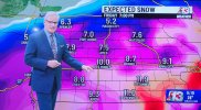
First call. Dry slot to contend with to the south. Still some questions on where the heaviest swath falls. That should be ironed out in the next 12 hours.

I do think we'll have big blowing/drifting snow and visibility issues with this one. "Drier" snow. Already full ditches. Stronger wind. I think gusts are around 45 mph through mid-day afternoon on Friday.


alarson

Well-Known Member
SuperFanatic
SuperFanatic T2
Mar 15, 2006
59,412
73,976
113
Ankeny
First call. Dry slot to contend with to the south. Still some questions on where the heaviest swath falls. That should be ironed out in the next 12 hours.

I do think we'll have big blowing/drifting snow and visibility issues with this one. "Drier" snow. Already full ditches. Stronger wind. I think gusts are around 45 mph through mid-day afternoon on Friday.


giphy.gif
 

bawbie

Moderator
Staff member
Mar 17, 2006
54,349
47,007
113
Cedar Rapids, IA
First call. Dry slot to contend with to the south. Still some questions on where the heaviest swath falls. That should be ironed out in the next 12 hours.

I do think we'll have big blowing/drifting snow and visibility issues with this one. "Drier" snow. Already full ditches. Stronger wind. I think gusts are around 45 mph through mid-day afternoon on Friday.


I'd guess we'll probably see Blizzard Warnings with this one?

I find it interesting that the NWS is understating the snowfall totals in the Watches and early information for both this storm and the last one. For example, the QC NWS issued a watch for 4-8", but the model guidance shows a 70% chance (huge for this far out, right?) of 8+" for parts of Eastern Iowa.
 

MNCYWX

Well-Known Member
Feb 7, 2010
2,300
973
113
WDM
I'd guess we'll probably see Blizzard Warnings with this one?

I find it interesting that the NWS is understating the snowfall totals in the Watches and early information for both this storm and the last one. For example, the QC NWS issued a watch for 4-8", but the model guidance shows a 70% chance (huge for this far out, right?) of 8+" for parts of Eastern Iowa.
Tis better to promise low early and build up than to promise a wallop early and have it bust. :)

I think this one does have a better prospect for Blizzard warnings. Snow consistency helps a lot. We shall see. They're Watch product didn't say that word but did say 'significant blowing and drifting snow'.
 
  • Like
Reactions: bawbie

BCClone

Well Seen Member.
SuperFanatic
SuperFanatic T2
Sep 4, 2011
67,551
63,602
113
Not exactly sure.
Fun stuff coming our way:

.WINTER STORM WATCH IN EFFECT FROM LATE THURSDAY NIGHT THROUGH
SATURDAY MORNING...

* WHAT...Heavy snow possible. Total snow accumulations of 6 to 10
inches. Winds could gust as high as 30 to 40 mph, resulting in
near whiteout conditions at times.

* WHERE...Northeast Iowa, southeast Minnesota, southwest into
central Wisconsin.

* WHEN...From late Thursday night through Saturday morning.

* IMPACTS...Travel could be very difficult. Blowing snow could
significantly reduce visibility. The hazardous conditions would
impact the morning and evening commute.
You need the moisture.
 

MNCYWX

Well-Known Member
Feb 7, 2010
2,300
973
113
WDM
Hi-Res models are significantly further north than the legacy global models. It should be pointed out one of the Hi-Res models drilled this last storm. And it is currently showing more of a northerly track with the snow vs southern Iowa.
 

alarson

Well-Known Member
SuperFanatic
SuperFanatic T2
Mar 15, 2006
59,412
73,976
113
Ankeny
Call me crazy but I'd much rather deal with snow than extreme cold. I'd sign up right now for 3 or 4 more of these big snows this year if it meant we didn't have to endure this upcoming stretch of temperatures.

I would generally agree. Though these big snows with no melt-off in between can make it hard to get the snow cleared.

Unfortunately we're getting the worst of both worlds. 20+" within a week followed by subzero
 
  • Like
Reactions: DFWClone

AirWalke

Well-Known Member
Aug 7, 2006
7,040
1,625
113
Des Moines
Just got a notification that lightning was detected within 15 miles of Waukee. We gettin’ some thundersnow tonight? :oops:

Edit: looks like some heavy bands are setting up to the west near Stuart and Earlham.
 

jsb

Well-Known Member
SuperFanatic
SuperFanatic T2
Mar 7, 2008
33,288
39,279
113
Just got a notification that lightning was detected within 15 miles of Waukee. We gettin’ some thundersnow tonight? :oops:

Edit: looks like some heavy bands are setting up to the west near Stuart and Earlham.

Snow squall warning. Those are recipes for huge pile ups on the interstate.