No forums found...
Site Related
Iowa State
College Sports
General - Non ISU
CF Archive
Install the app
How to install the app on iOS
Follow along with the video below to see how to install our site as a web app on your home screen.
Note: This feature may not be available in some browsers.
Weather Thread - 1/16 to 1/18
- Thread starter CyState85
- Start date
No forums found...
Site Related
Iowa State
College Sports
General - Non ISU
CF Archive
You are using an out of date browser. It may not display this or other websites correctly.
You should upgrade or use an alternative browser.
You should upgrade or use an alternative browser.
6-8" with 20 mph winds. Should be a fun one! I always secretly hope that my wife makes it to work and my kids to daycare, and then on her way home, she gets the kids and gets stranded at her parents. Hasn't happened yet in the 4 years we've been in our current house....shame.

Thniking the upper end 8" -12" is likely for Mpls for no other reason than I am hosting a neighborhood party Saturday. So, of course, I'll be spending my shopping and food prep time shoveling instead.
can i come

Have been planning on taking Friday off for some time already. I will be VERY happy to not have to leave the house at all. Yay for four-day weekends (thanks MLK Jr. holiday)!
can i come
Sure, but remember it's a BYOHAB*.
* Bring Your Own Hookers and Blow.
Sure, but remember it's a BYOHAB*.
* Bring Your Own Hookers and Blow.
they will already be dead
dont want to make a mess in ur home
im courteous like that
Very wide, 30,000 ft view first impression here.
I'm still leaning toward the under, or low end. Bad placement of surface low compared to a traditional state/C. Iowa-wide heavy snow event. Lots of warm air being pumped in.
At the moment, I expect precip type issues and/or a substantial warm layer aloft that crushes the snow ratios, especially southern half of Iowa. I'll get into it a bit more seriously this afternoon, but this looks odd.

I'm guessing the twin cities get nailed but feel like the DSM metro will get 1-3. Just my wild guessing.
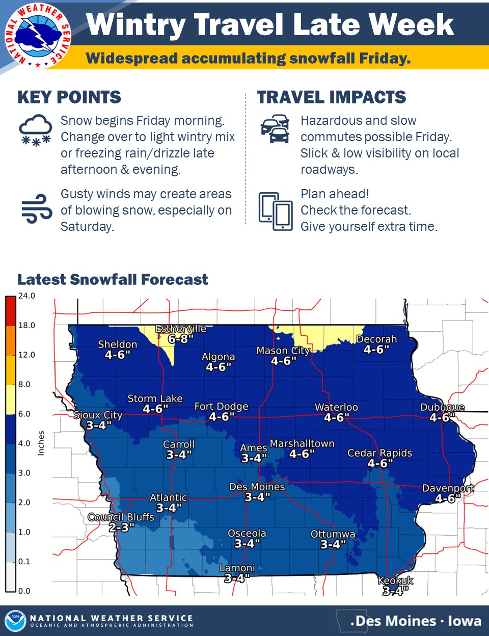
KCCI saying 3-5 inches now for Des Moines. It’s tracking north seems like. Probably will end up being 2-3 prediction by Friday morning.I'm guessing the twin cities get nailed but feel like the DSM metro will get 1-3. Just my wild guessing.
Very wide, 30,000 ft view first impression here.
I'm still leaning toward the under, or low end. Bad placement of surface low compared to a traditional state/C. Iowa-wide heavy snow event. Lots of warm air being pumped in.
At the moment, I expect precip type issues and/or a substantial warm layer aloft that crushes the snow ratios, especially southern half of Iowa. I'll get into it a bit more seriously this afternoon, but this looks odd.

Interesting in that the ECMWF and NAM are trending colder, while the GFS remains the odd man out with warmer temperatures. No matter what, it's going to be messy.Very wide, 30,000 ft view first impression here.
I'm still leaning toward the under, or low end. Bad placement of surface low compared to a traditional state/C. Iowa-wide heavy snow event. Lots of warm air being pumped in.
At the moment, I expect precip type issues and/or a substantial warm layer aloft that crushes the snow ratios, especially southern half of Iowa. I'll get into it a bit more seriously this afternoon, but this looks odd.
D
Deleted member 8507
Guest
I hadn't heard about this. So, how are customers going to get a coupon or rebate?
https://www.kcrg.com/content/news/E...GTZythUunXLy3P8w2ti3T_qtKWal5v-hqrdZdmcYxexbs
https://www.kcrg.com/content/news/E...GTZythUunXLy3P8w2ti3T_qtKWal5v-hqrdZdmcYxexbs
Attachments

Also surprised kids aren’t dismissing early this afternoon in anticipation for Friday’s snow.Kinda surprised we haven't seen school closings for Friday already. The night before is no longer acceptable, we need at least two days notice now just to prepare for the day before the big storm gets here.