Cedar Rapids flooding

VeloClone

Well-Known Member
Jan 19, 2010
48,340
39,106
113
Brooklyn Park, MN
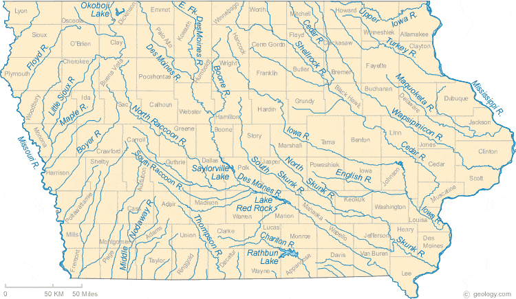
The Cedar is a tributary of the Iowa, so it some point it's all the same watershed. But what falls in Garner does not end up in Cedar Rapids. What falls in Mason City does.
iowa-rivers-map.gif
 

Tre4ISU

Well-Known Member
SuperFanatic
SuperFanatic T2
Dec 30, 2008
28,201
9,318
113
Estherville
The rain in the upper reaches of the watershed has been insane. I bet there's been over 30 inches of rain in much of NC/NE IA since the end of July. It just doesn't stop. There's gonna be a **** load of corn in the field this winter the way it's going.

To put it in perspective, the Greene area got more rain last night than it did in all of 2012, IIRC.

Definitely possible. Those guys are going to have to hope for a real cold, real early winter like 2014.
 

Gonzo

Well-Known Member
Mar 10, 2009
26,649
30,906
113
Behind you
I was in CR in 08 working close to downtown and we were knocked out of our building for a year.
 

exCYtable

Well-Known Member
Apr 15, 2010
4,753
8,424
113
The river got way higher way faster than anyone expected last time. It was unreal.
That's the biggest problem and that's why they are taking this so seriously. If CR gets the amount of rain that Ames just got in the last 30 minutes, along with what's forecast this weekend, it could be really, really bad. The unpredictability of the next 72 hours of rainfall has to be frightening.
 

wxman1

Well-Known Member
SuperFanatic
SuperFanatic T2
Jul 2, 2008
19,905
16,272
113
Cedar Rapids
Clarksville is expecting a levy to breach and has put out a mandatory evacuation for anyone that was affected by the 2008 floods. Bad news for them but can be good news for those downstream.
 

ISUAlum05

Active Member
Nov 5, 2007
632
46
28
Cedar Rapids, IA
That's the biggest problem and that's why they are taking this so seriously. If CR gets the amount of rain that Ames just got in the last 30 minutes, along with what's forecast this weekend, it could be really, really bad. The unpredictability of the next 72 hours of rainfall has to be frightening.
It has rained almost zero in Cedar Rapids.
 

BigJCy

Well-Known Member
Apr 11, 2006
24,828
21,719
113
With the amount of rain Ames has gotten tonight we might need to start a "Ames/Story County Flooding" thread...hopefully not. Good Lord.
 

cc1091

Well-Known Member
Oct 10, 2007
1,146
305
83
Minneapolis
Lets build in a flood plain :confused:

^ ^ ^- A** - ^ ^ ^

Has probably never been to Cedar Rapids and is totally unaware of its topography or the tributaries to the Cedar. Like every other city, established at a good crossing of the river.

Maximum river height 20' feet recorded in 1859 and 1928, until the 2008 flood of 31 feet. 24 predicted this time. Definitely NOT a flood plain.
 
  • Like
Reactions: wxman1

CloneinWDSM

Well-Known Member
Aug 9, 2013
16,761
11,443
113
There's ankle deep water on Welch and Lincoln way according to the Twitter box.
 

cc1091

Well-Known Member
Oct 10, 2007
1,146
305
83
Minneapolis
Parts of town got around an inch of rain from tha storm around six tonight. More rain overnight as well as forecasted for Sunday.

Prior to that storm at six, very little rain in the locality. Yet the river was already predicted to crest at 24 feet in a few days. Its not lack of planning in CR. Its an unusual amount of rain happening hundreds of miles to the north, and then improper river management from Waterloo north. That big basin in Waterloo is easily overpowered unless it is left to drain PRIOR to any event. This probably means keeping the level lower in Waterloo, which will make all of those lakes around George Wythe Park less attractive recreation destinations.

Until this is corrected, rains in North Iowa and Waterloo will be the reason why the Cedar floods.
 
  • Like
Reactions: 1UNI2ISU

BoxsterCy

Moderator
Staff member
Sep 14, 2009
48,228
47,062
113
Minnesota
Prior to that storm at six, very little rain in the locality. Yet the river was already predicted to crest at 24 feet in a few days. Its not lack of planning in CR. Its an unusual amount of rain happening hundreds of miles to the north, and then improper river management from Waterloo north. That big basin in Waterloo is easily overpowered unless it is left to drain PRIOR to any event. This probably means keeping the level lower in Waterloo, which will make all of those lakes around George Wythe Park less attractive recreation destinations.

Until this is corrected, rains in North Iowa and Waterloo will be the reason why the Cedar floods.

Of course it is the runoff upstream but there are no flood control reservoirs upstream of CR . A handful of run of river low head dams have zero effect on the flooding downstream at CR. Has some limited impact on low flow regime but zippo during high water events.
 

cc1091

Well-Known Member
Oct 10, 2007
1,146
305
83
Minneapolis
That the congress has approved the building of a better flood retention system in Cedar Rapids is significant. That congress has also not provided any funding for that system is also significant. Look to the leadership provided by Chuck Grassley (I'm kidding, there was no leadership provided by him, his latest words implied that we should give up on getting funds to help support the building of this system).

All it takes for catastrophes to happen, is for good men to fail to do what they know is right.
 

NWICY

Well-Known Member
Sep 2, 2012
35,288
31,420
113
Clarksville levee gave way, probably some relief for towns downstream. Sounds like Ames is getting pounded, not good for tailgating this weekend. :(
 
  • Dislike
Reactions: Dormeezy

NWICY

Well-Known Member
Sep 2, 2012
35,288
31,420
113
Clarksville levee gave way, probably some relief for towns downstream. Sounds like Ames is getting pounded, not good for tailgating this weekend. :(