My app shows a flood watch in areas north and south of I-80 from the middle eastern 2/3 of Nebby to just Newton then along I-35 from Des Moines stretching to Northern Minny.
No forums found...
Site Related
Iowa State
College Sports
General - Non ISU
CF Archive
Install the app
***Official 2024 Weather Thread***
- Thread starter wxman1
- Start date
No forums found...
Site Related
Iowa State
College Sports
General - Non ISU
CF Archive
You are using an out of date browser. It may not display this or other websites correctly.
You should upgrade or use an alternative browser.
You should upgrade or use an alternative browser.
Things popping in NW Iowa tonight.
Recent or active thunderstorm warnings that include:
*golf-ball sized hail (Larrabee, Marcus, Calumet, Paullina, Aurelia)
*2" hail (Sanborn, Hartley, Ashton, Ocheyedan, Spencer, Mallard, Havelock)
*baseball-sized hail (Pocahontas, Laurens)
*tennis ball-sized hail (Dickens, Webb)
*3" hail (Sioux Rapids, Royal)
Thank god I don't know where any of those places are, must mean I'm safe for now.Things popping in NW Iowa tonight.
Recent or active thunderstorm warnings that include:
*golf-ball sized hail (Larrabee, Marcus, Calumet, Paullina, Aurelia)
*2" hail (Sanborn, Hartley, Ashton, Ocheyedan, Spencer, Mallard, Havelock)
*baseball-sized hail (Pocahontas, Laurens)
*tennis ball-sized hail (Dickens, Webb)
*3" hail (Sioux Rapids, Royal)
Things popping in NW Iowa tonight.
Recent or active thunderstorm warnings that include:
*golf-ball sized hail (Larrabee, Marcus, Calumet, Paullina, Aurelia)
*2" hail (Sanborn, Hartley, Ashton, Ocheyedan, Spencer, Mallard, Havelock)
*baseball-sized hail (Pocahontas, Laurens)
*tennis ball-sized hail (Dickens, Webb)
*3" hail (Sioux Rapids, Royal)
Is there really enough difference between a baseball and tennis ball to necessitate a distinction?
Iphone iOS 17.4.1
Look at your notification settings for your weather app. For some reason it is in a different place than other warnings such as Amber alerts.
Is there really enough difference between a baseball and tennis ball to necessitate a distinction?
That's the verbage that was used. I also saw one for "large apple."
I don't think my sump has ever ran, it's bone dry currently. But we are on the top of a hill here.This is a statement of a person with high confidence in their sump pump and drainage system.
There has been a cell like 5 miles south and east of us that hasn’t moved in an hour. Light show has been impressive. Dalmatian is not impressed though. Currently shaking in bed between me and the gf. Gonna be a long night.
Harlan areagot a deluge tonight it looks like. Flash flooding.
Pretty wild flash flood warning circle with that one.
Baseball is heavier, packs a bigger punch.Is there really enough difference between a baseball and tennis ball to necessitate a distinction?
Storm just sat there for well over an hour or two with heavy rain.Pretty wild flash flood warning circle with that one.
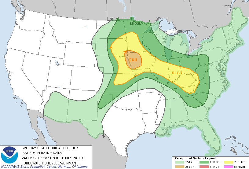
SPC Day 1 Outlook
Severe weather, tornado, thunderstorm, fire weather, storm report, tornado watch, severe thunderstorm watch, mesoscale discussion, convective outlook products from the Storm Prediction Center.
www.spc.noaa.gov

Tennis ball hail tends to bounce more than baseball sized hail!Is there really enough difference between a baseball and tennis ball to necessitate a distinction?
SPC Day 1 Outlook
Severe weather, tornado, thunderstorm, fire weather, storm report, tornado watch, severe thunderstorm watch, mesoscale discussion, convective outlook products from the Storm Prediction Center.www.spc.noaa.gov
This is getting worse, not better.


