No forums found...
Site Related
Iowa State
College Sports
General - Non ISU
CF Archive
Install the app
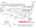
Map of USA labeled by an Aussie who's never been here...
- Thread starter ImJustKCClone
- Start date
No forums found...
Site Related
Iowa State
College Sports
General - Non ISU
CF Archive
You are using an out of date browser. It may not display this or other websites correctly.
You should upgrade or use an alternative browser.
You should upgrade or use an alternative browser.
When I was in Australia and said I was from Iowa most people had no clue.
If I said Midwest they nodded like at least they felt like it was a word that could mean something directionally.
A couple times I said it was next to the Mississippi River and they automatically assumed it was in the South, because to most people who know about racism know Mississippi is in the South.
Best answer was "3 hours West of Chicago."
When we travel and people ask where we're from, we usually tell them "Iowa - which is pretty much in the middle of the USA".
"I don't care" perfectly describes Missouri.
Probably my favorite although Florida aka penis gun is a close second.
USA is a lot more like Eurasia. Culturally and borders are wild and divergent.
Its mostly just timing.
Eastern US developed earlier, transportation was horse-powered or over-river. Borders mostly followed natural features like rivers and population (that developed along rivers).
The western US and australia developed populations later. Trains (and later cars) were the prime modes of transportation, so they were created more square. And when these states were created, there was relatively little population in them at all, so they were larger (some of the western states, especially CA, would probably be multiple states if created today). Most of Australia, outside of its east coast, is still sparsely populated. There's only 25 million in the whole country, and 80% of those live along the east coast.
Plus, as you go west there are fewer big flowing rivers that are tough to cross - making natural borders. In vast flat areas it's easier to just draw a straight line on some random latitude or longitude.Its mostly just timing.
Eastern US developed earlier, transportation was horse-powered or over-river. Borders mostly followed natural features like rivers and population (that developed along rivers).
The western US and australia developed populations later. Trains (and later cars) were the prime modes of transportation, so they were created more square. And when these states were created, there was relatively little population in them at all, so they were larger (some of the western states, especially CA, would probably be multiple states if created today). Most of Australia, outside of its east coast, is still sparsely populated. There's only 25 million in the whole country, and 80% of those live along the east coast.
They honestly did pretty well just coming up with names of states if they've never been here. If you had me do a similar exercise there I think all I could really label would be Sydney(ish) and circle like the entire middle and label it "the outback", oh and the little island nub at the bottom is Tasmania, which I know because of googling the cartoon character as a kid.
They honestly did pretty well just coming up with names of states if they've never been here. If you had me do a similar exercise there I think all I could really label would be Sydney(ish) and circle like the entire middle and label it "the outback", oh and the little island nub at the bottom is Tasmania, which I know because of googling the cartoon character as a kid.
Agree. I think my map of Australia would just be two zones. Where people live and where people don’t.
About half the kids coming out of high school today could not do any better. Which is sad.
Except by the last one he got distracted and almost called it directional Vagina.My favorites are (so far):
- Wibbly Rectangle
- Virginia directional quintuplicate
I think the best is his comment that Australia has "six maby seven state." That seems like something that shouldn't include a maybe. Sorry, a "maby."
I got more time to review in-full. So many highlights.
- Alaska as "Left Canada." Sounds like a directional college.
- Missouri: I Don't Care. Seems about right.
- Nevada: Kite. Heh!
- Arizona is "Almost Mexico"; would've been funnier for New Mexico.
- NH/Vt: Puzzle pieces. ... It does look like that!
- "We have six maby seven state." ... Maby!
KidSilverhair
Well-Known Member
You mean there are times that they aren't?Awesome. Australian people must be a blast when they are drinking.


