No forums found...
Site Related
Iowa State
College Sports
General - Non ISU
CF Archive
Install the app
***Official 2025 Weather Thread***
- Thread starter wxman1
- Start date
No forums found...
Site Related
Iowa State
College Sports
General - Non ISU
CF Archive
You are using an out of date browser. It may not display this or other websites correctly.
You should upgrade or use an alternative browser.
You should upgrade or use an alternative browser.
Now the question becomes if it can get to high risk. I’m guessing no.
Now the question becomes if it can get to high risk. I’m guessing no.
A moderate rating this early? It’s going to get there. It’ll probably be based on what the primary threat is. If a widespread tornado outbreak is expected, we might see High risk as far down as KC.
So this is quite the significant uptick of severe weather wordage from the SPC, they are not pulling any punches with that day 3 wording: https://www.spc.noaa.gov/products/outlook/day3otlk.html
NWS Des Moines is also increasingly bullish on strong tornadoes https://forecast.weather.gov/produc...MX&product=AFD&format=CI&version=1&glossary=1 and so is NWS Minneapolis https://forecast.weather.gov/produc...PX&product=AFD&format=CI&version=1&glossary=1.
The CSU-MLP AI model is showing the highest tornado risk as over northeast Iowa north of I-80 and east of I-35, going into SE Minnesota and SW Wisconsin. They are also showing a hail risk dipping into central Iowa- it seems to me that the AI believes that if supercells can fire, they could fire over Ames/Des Moines, rapidly upscale, and start dropping big tornadoes a little bit further east (but this is just one model)

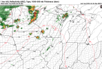
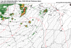
The higher resolution models are just starting to get into range of the event, they mostly haven't reached the initiation point which is likely 3-5pm but here's the NAM from 1am last night at 1pm on Monday, as well as HRRR from 7am this morning at 7am on Monday, notice we DO have full cloud cover in Iowa which could dampen the threat a little and preclude a high risk:


The RRFS is a convecting allowing model that goes out through the entire event, here are snapshots of 5pm and 7pm. This model likes to depict supercells forming starting in western Minnesota, rapidly moving upscale and forming a broken line around Minneapolis, while some more supercells form in NE Iowa and Missouri. Very isolated behavior which is unfortunately more conductive to long track supercells that can drop large, violent tornadoes.


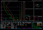
4pm Monday sounding for Ames, IA on the GFS:

Upper 67 dew points, high amount of instability (CAPE) in the 3000s will promote massive updrafts to give those scary green skies right before a bad storm. 56 knots of shear and curved hodographs will promote a tornado threat. The SRH (helicity) isn't low but not overly strong, and we do have that elevated mixed layer (that "<" shape in the green line at the 3km in the skew-T on the upper left) which mean there will be a cap and not everyone will see storms. There is a chance storms may not fire at all in central IA down into Oklahoma until at least the cold front passes through, which would basically save everyone here from the strong tornado threat.
Below is another sounding from Waterloo, IA, also 4pm GFS. Much more low level curvature in the hodograph and higher SRH values in the 200s though still not the highest. Still a strong cap, so storms will be discrete if they do fire. I do still think the biggest strong tornado threat will be in eastern Iowa east of I-35 up to Minneapolis, mainly from 3PM to 7PM.

NWS Des Moines is also increasingly bullish on strong tornadoes https://forecast.weather.gov/produc...MX&product=AFD&format=CI&version=1&glossary=1 and so is NWS Minneapolis https://forecast.weather.gov/produc...PX&product=AFD&format=CI&version=1&glossary=1.
The CSU-MLP AI model is showing the highest tornado risk as over northeast Iowa north of I-80 and east of I-35, going into SE Minnesota and SW Wisconsin. They are also showing a hail risk dipping into central Iowa- it seems to me that the AI believes that if supercells can fire, they could fire over Ames/Des Moines, rapidly upscale, and start dropping big tornadoes a little bit further east (but this is just one model)

The higher resolution models are just starting to get into range of the event, they mostly haven't reached the initiation point which is likely 3-5pm but here's the NAM from 1am last night at 1pm on Monday, as well as HRRR from 7am this morning at 7am on Monday, notice we DO have full cloud cover in Iowa which could dampen the threat a little and preclude a high risk:


The RRFS is a convecting allowing model that goes out through the entire event, here are snapshots of 5pm and 7pm. This model likes to depict supercells forming starting in western Minnesota, rapidly moving upscale and forming a broken line around Minneapolis, while some more supercells form in NE Iowa and Missouri. Very isolated behavior which is unfortunately more conductive to long track supercells that can drop large, violent tornadoes.


4pm Monday sounding for Ames, IA on the GFS:

Upper 67 dew points, high amount of instability (CAPE) in the 3000s will promote massive updrafts to give those scary green skies right before a bad storm. 56 knots of shear and curved hodographs will promote a tornado threat. The SRH (helicity) isn't low but not overly strong, and we do have that elevated mixed layer (that "<" shape in the green line at the 3km in the skew-T on the upper left) which mean there will be a cap and not everyone will see storms. There is a chance storms may not fire at all in central IA down into Oklahoma until at least the cold front passes through, which would basically save everyone here from the strong tornado threat.
Below is another sounding from Waterloo, IA, also 4pm GFS. Much more low level curvature in the hodograph and higher SRH values in the 200s though still not the highest. Still a strong cap, so storms will be discrete if they do fire. I do still think the biggest strong tornado threat will be in eastern Iowa east of I-35 up to Minneapolis, mainly from 3PM to 7PM.

Attachments
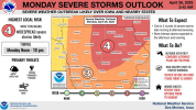
Day 3, 45% hatched is essentially the top of the scale, so high risk isn't a complete stretch at this point.
View attachment 148540 View attachment 148542
Don't love this but once again, probably appreciate that I moved east burbs and not west burbs.
Alliant Energy just sent this email. We have them for gas, city of Ames for electric:
The National Weather Service has forecast severe storms in Iowa and Wisconsin on Monday afternoon and night, April 28. Large hail, damaging winds and tornadoes are possible.
Our crews are prepared to safely respond to any power outages the storm causes. If you see downed lines, please let us know by calling 1-800-ALLIANT (800-255-4268).


The latest NAM is out and goes to 7pm Monday, this is 6-7 pm. Not much convection even in Minnesota- there are a few small cells that pop up in western Iowa but they quickly disintegrate.
6pm Ames on the NAM. Circled in red is our culprit that I mentioned- a lot of dry air at the mid levels that are preventing storms from convecting down to the surface, and not much low level shear to provide forcing (995-996 MB is not that strong of a low pressure system). Low level helicity is even more mid at 130 m2/s2. If models continue to show this, well, NWS Des Moines already said the threat could be quite conditional yesterday, I was kind of surprised the SPC even pulled the trigger on the moderate risk on Day 3 if it's this conditional so far.

Attachments
Well I'm not the most confident that SPC should have given a moderate risk already on Day 3, as there's a decent chance Iowa just doesn't get storms until late in the evening when the best chance for tornadoes have already passed.
New rule, 48 hours out is the max you can freak out over potential severe weather.
Yeah, but it was pretty slow—-they didn’t get all 5 at once. They are surprised at how high it is. They’ve been here 43 years and are good at predicting what the creek will do and this surprised them. The neighbors are also wondering what’s up.
Hopefully they don’t get one of those 6 inches in a night because they’d probably be floating.
Dang it JSB you tee this up yet I restrained myself. You make it so hard for me to be well behaved.
For reference, Day 3 Greenfield last year:
Storm Prediction Center May 19, 2024 0730 UTC Day 3 Severe Thunderstorm Outlook
Severe weather, tornado, thunderstorm, fire weather, storm report, tornado watch, severe thunderstorm watch, mesoscale discussion, convective outlook products from the Storm Prediction Center.
www.spc.noaa.gov
View attachment 148550
View attachment 148548
The latest NAM is out and goes to 7pm Monday, this is 6-7 pm. Not much convection even in Minnesota- there are a few small cells that pop up in western Iowa but they quickly disintegrate.
6pm Ames on the NAM. Circled in red is our culprit that I mentioned- a lot of dry air at the mid levels that are preventing storms from convecting down to the surface, and not much low level shear to provide forcing (995-996 MB is not that strong of a low pressure system). Low level helicity is even more mid at 130 m2/s2. If models continue to show this, well, NWS Des Moines already said the threat could be quite conditional yesterday, I was kind of surprised the SPC even pulled the trigger on the moderate risk on Day 3 if it's this conditional so far.
View attachment 148552
Everything is conditional until it happens. That's just the way it is. Doesn't matter how much data is available.
Where I live was hit by an F0-1 last year.....no watches, warnings, sirens or even one of those "radar indicated" alerts. Nothing....until we saw debris going up and trees being shredded. No time to even get to shelter. Thankfully it wasn't a classic grinder because it caught everyone off guard and the outcome would have been a disaster and much more than just some structure and veggie damage.
As for Monday.......somewhere in the midwest will get hit by something. That seems certain. How hard and by what is still up in the air....no pun intended. Could end up being a wind and hail bomb with all the mid level dry air. Those are no fun either. Hopefully whatever happens....if it happens, is no worse than what hit our neighborhood (bad enough) and not what hit Barneveld, Wisconsin 1984. Because that is what everyone is ballooning this into.
As an aside, the warning sirens did go off in our area and TV8 came on with their "umbrella of safety" broadcast warning us of a possible tornado.......5-10 minutes after the damage was done, the rain and wind had stopped and it was gone. Like I said..........conditional until it happens.
TBH I'll likely be spending the entire afternoon and evening in my basement regardless. Hoping to still have a house by Tuesday...Everything is conditional until it happens. That's just the way it is. Doesn't matter how much data is available.
Where I live was hit by an F0-1 last year.....no watches, warnings, sirens or even one of those "radar indicated" alerts. Nothing....until we saw debris going up and trees being shredded. No time to even get to shelter. Thankfully it wasn't a classic grinder because it caught everyone off guard and the outcome would have been a disaster and much more than just some structure and veggie damage.
As for Monday.......somewhere in the midwest will get hit by something. That seems certain. How hard and by what is still up in the air....no pun intended. Could end up being a wind and hail bomb with all the mid level dry air. Those are no fun either. Hopefully whatever happens....if it happens, is no worse than what hit our neighborhood (bad enough) and not what hit Barneveld, Wisconsin 1984. Because that is what everyone is ballooning this into.
As an aside, the warning sirens did go off in our area and TV8 came on with their "umbrella of safety" broadcast warning us of a possible tornado.......5-10 minutes after the damage was done, the rain and wind had stopped and it was gone. Like I said..........conditional until it happens.
Conditional here means there is a lot of discrepancy between possibilities. We could see zero storms throughout Iowa until at least the main threat has passed. We could see a big scale tornado outbreak. I think this is more in line with April 26, 2024 than May 21st- it could go big or it could bust hard depending on how strong the cap and forcing is.
https://www.spc.noaa.gov/products/outlook/day3otlk.html Latest update just dropped. Notably the entire Minneapolis metro is now in the highest hatched risk area.


