***Official 2024 Weather Thread***

MNCYWX

Well-Known Member
Feb 7, 2010
2,302
978
113
WDM
That second round that came through the metro could have been worse if we didn't have the prior storms. The atmosphere was pretty worked over and that second round 'elevated' as the moved into central Iowa.

No doubt there were some spots that did receive that damaging wind 60+ but it wasn't widespread in that warned area as it moved through. I'd estimate 40-50 was more common on a widespread level. With the the first round it helped stabilize things at the surface which makes it bit harder to punch that strongest wind to the surface. Not only that but a lot of it actually started deviating to the south which followed the instability gradient/outflow from the first round. Was a bit more potent in SW Iowa and S Iowa near the border.

I saw a couple posts on the socials about the 90 mph wind in Omaha coming towards the DSM metro. The likelihood of that actually happening in central Iowa was actually quite low because of this.
 
  • Like
Reactions: aauummm

BoxsterCy

Moderator
Staff member
Sep 14, 2009
48,355
47,270
113
Minnesota
I'd like to see a similar map for Iowa. You can catch the border counties a little bit. That's a lotta rain in two weeks especially coming on the heels of two years of drought conditions for much of the state.

 
  • Wow
Reactions: BACyclone

jsb

Well-Known Member
SuperFanatic
SuperFanatic T2
Mar 7, 2008
33,338
39,372
113
I'd like to see a similar map for Iowa. You can catch the border counties a little bit. That's a lotta rain in two weeks especially coming on the heels of two years of drought conditions for much of the state.


Areas in Western Iowa had 18 inches in 3 days.
 

mapnerd

Well-Known Member
Aug 17, 2006
4,252
2,670
113
47
Ames


Pretty crazy. I think NWS in that region really dropped the ball last night.

——
I’m surprised a tornado could find anyone out there, but I guess it did.
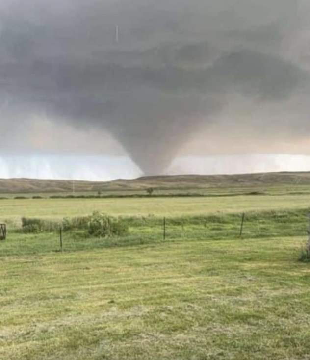

We were livestreaming a youtuber last night (max velocity?) and he was amazed that they didn't get a tornado warning to those people in time. It took the NWS a very long time when he saw it way before. Good thing no one was killed.
 

BoxsterCy

Moderator
Staff member
Sep 14, 2009
48,355
47,270
113
Minnesota
All of this rain reminds a little of 1993 when we had summer flooding. I attended a post-flood conference in the Quad Cities. Think it was billed as some sort of mayor's conference. Post flood there is always all sorts of second guessing and finger pointing from a lot of folks*** who should just talk less and listen more. I do remember the chief hydrologist from the Corps of Engineers Rock Island District speaking. Went something like this "I am going to tell you why it flooded so bad" Mayors and local officials were all ears awaiting the reveal of some secret or some huge error by the feds or the states that caused everything. "Well, it rained." Big pause and than "It rained a lot. And than it rained some more!" And the mayors all slumped back into their chairs. I was chuckling to myself.

*** Example: "The flood control project downstream of me caused my flooding!" "The flood control project upstream of me caused my flooding!" "The reservoir upstream could have prevented my flooding!"
 

Turn2

Well-Known Member
May 12, 2011
22,591
26,964
113
Clusterfunkeny
We were livestreaming a youtuber last night (max velocity?) and he was amazed that they didn't get a tornado warning to those people in time. It took the NWS a very long time when he saw it way before. Good thing no one was killed.
The county where Mullen, NE is located has roughly one person per square mile. They either know what’s coming or aren’t paying attention anyway.
 

mapnerd

Well-Known Member
Aug 17, 2006
4,252
2,670
113
47
Ames
The county where Mullen, NE is located has roughly one person per square mile. They either know what’s coming or aren’t paying attention anyway.
Oh the things I could do with one square mile of land.
 

NorthCyd

Well-Known Member
SuperFanatic
SuperFanatic T2
Aug 22, 2011
21,190
35,816
113
I'd like to see a similar map for Iowa. You can catch the border counties a little bit. That's a lotta rain in two weeks especially coming on the heels of two years of drought conditions for much of the state.


If anyone is interested in seeing rainfall totals and other data pertinent to floods I would recommend the Iowa Flood Information System. It has some pretty good interactive tools you can use to look at different types of data.

 
  • Informative
Reactions: NWICY

Letterkenny

Well-Known Member
SuperFanatic
SuperFanatic T2
Oct 26, 2023
1,778
3,613
113
All of this rain reminds a little of 1993 when we had summer flooding. I attended a post-flood conference in the Quad Cities. Think it was billed as some sort of mayor's conference. Post flood there is always all sorts of second guessing and finger pointing from a lot of folks*** who should just talk less and listen more. I do remember the chief hydrologist from the Corps of Engineers Rock Island District speaking. Went something like this "I am going to tell you why it flooded so bad" Mayors and local officials were all ears awaiting the reveal of some secret or some huge error by the feds or the states that caused everything. "Well, it rained." Big pause and than "It rained a lot. And than it rained some more!" And the mayors all slumped back into their chairs. I was chuckling to myself.

*** Example: "The flood control project downstream of me caused my flooding!" "The flood control project upstream of me caused my flooding!" "The reservoir upstream could have prevented my flooding!"
There is something to the human tendency to follow every natural disaster with "Why didn't we see it coming and build for it?" In my line of work I'll sometimes have people ask me why we don't build houses to withstand tornadoes. Well, you can if you want to live in a concrete bunker with no windows or live underground. Or you can build a nicer wood house above ground, that's way cheaper and accept that there is a 1/10,000 chance it takes a direct hit from a tornado in the next 50-100 years.