

No forums found...
Site Related
Iowa State
College Sports
General - Non ISU
CF Archive
Install the app
How to install the app on iOS
Follow along with the video below to see how to install our site as a web app on your home screen.
Note: This feature may not be available in some browsers.
3/24 Snow Storm
- Thread starter wxman1
- Start date
No forums found...
Site Related
Iowa State
College Sports
General - Non ISU
CF Archive
You are using an out of date browser. It may not display this or other websites correctly.
You should upgrade or use an alternative browser.
You should upgrade or use an alternative browser.
Any shifting in this storm more south to the Iowa City area, or are we looking for only a few inches?
Any shifting in this storm more south to the Iowa City area, or are we looking for only a few inches?
It sure doesn't look like anything on the radar at the moment - just a little rain and gone.
Or is it the 2nd wave still out in Nebby that is going to be delivering the power dump?
Or is it the 2nd wave still out in Nebby that is going to be delivering the power dump?
It sure doesn't look like anything on the radar at the moment - just a little rain and gone.
Or is it the 2nd wave still out in Nebby that is going to be delivering the power dump?


I have to drive from Ames to Fort Dodge tomorrow. Can this crap please to northeast?
"Warm" soil and roads + rain first = relatively easy clean up and decent road conditions thereafter.
My favorite part is the darker yellow north of Waterloo out of frame where I live.
**** you weather.
It sure doesn't look like anything on the radar at the moment - just a little rain and gone.
Or is it the 2nd wave still out in Nebby that is going to be delivering the power dump?
Not picking on you but weather is dynamic and constantly changing. The answer to your question is yes and no. Yes we will be getting what is now in central Iowa and moving into eastern IA and no in the fact that it will also fill in. Weather develops and dissipates it doesn't just move as blob all across the country at the same intensity and coverage area.
Not a chance that happens. It would have to switch to snow very quickly and accumulate just as quick to overcome ground temps.
In NE CR right now we are sitting at 43 and dropping with 44% humidity and rising.
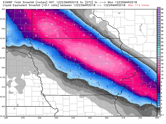
According to this map Garner, IA will see the brunt of this storm 15" (little pink speck on the map) Jim Cantore better be giving his reports at my house.Earl thinks this is being blown out of proportion and people need to be more reasonable, which is his usual stance:
http://www.grib2.com/gfs/WINTER_GFS0P5_SFC_ACCUM-SNOW_168HR.gif

Looks like at least 4" if not up to 8 or more is still on track for the 380 corridor towards the QC. Precip approaching CR thought we heard some rumbles of thunder but it very well could have been the wind too as that is blowing pretty good as well. Temp has only fallen to 41 thus far but is falling at a bit greater rate. DP now at 47%.
Not a chance that happens. It would have to switch to snow very quickly and accumulate just as quick to overcome ground temps.
In NE CR right now we are sitting at 43 and dropping with 44% humidity and rising.
I thought the same thing last Friday night, going to bed during a thunderstorm, and waking up to 10" of snow at 7 AM Saturday morning. These late season snow storms can drop a lot of snow in a very short amount of time.
I've been a global warming denier until now. This thead, and your post, have given me all the proof I need.
Sarcasm noted. The temperatures at the North Pole in February 2018 (above freezing) were what is normally expected in May or even June there. Normally circumpolar air, produced in the 24 hour darkness, stays around the pole. But due to an expansive region of super warm water in the western Pacific, warm moist air has surge north displacing Arctic masses. That cold air has then been sliding SE over us almost continuously since late October. Wait until this La Nina abates, you will enjoy it.
By the way the cold we experienced was one of the few areas in the entire world reporting abnormally cool temps. Much of the globe is above of average.
That is why Science calls it Climate Change (snow in Florida and warmer there than Alaska recently). If you have trouble with the Science, please don't use your cellphone, seek modern medicine or even be weighed down by gravity. Since Science has accurate theories on those too.
Last edited: