***Official 2024 Weather Thread***

MJ29

Well-Known Member
Aug 21, 2020
2,627
5,413
113
Community facebook page tells me 3K homes in Grimes without power. (MidAmerican) Supposed to be restored by 12:30.
 

madguy30

Well-Known Member
Nov 15, 2011
50,233
47,098
113
Planning on camping along the Mississippi River this weekend. That forecast keeps calling for colder and colder temps.

Kind of prefer it if it means keeping crowds away.
 
  • Like
Reactions: wxman1

NorthCyd

Well-Known Member
SuperFanatic
SuperFanatic T2
Aug 22, 2011
17,585
27,798
113
Speaking of which … not only am I in a freshly issued tornado watch area (along with the Cedar Rapids NWS radio station being off the air :rolleyes:), I’m planning on tacos tonight.

Assuming my home isn’t swept away by Tornadogeddon Lollapalooza 24, of course.

Oh man, those are even taco bravos! Now I'm hungry for tacos!
 

cstrunk

Well-Known Member
Mar 21, 2006
14,261
4,537
113
36
Longview, TX
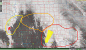
1713291916415.png

Here's where I see the highest tornado threat over the next few hours, red to yellow, from higher to lower. SE IA/NE MO has the best mix of instability and kinematics. The farther NW you go, less instability, but still good kinematics. And tornadoes (albeit weaker, possibly landspout-type tornadoes) possible in more of a "cold-core" type setup around the low pressure center. Severe wind/hail all possible as storms move northeast, still carrying a bit of a tornado threat.

Disclaimer: I'm not a meteorologist. And not surprisingly, this lines up pretty closely to the SPC's convective outlook.

*Edit - I'll add that the IA/MO border region south into NE MO has the best chance at seeing more isolated supercells with highest tornado threat.
 
  • Like
  • Informative
Reactions: MJ29 and wxman1

Latest posts

Help Support Us

Become a patron