I have had over 4.5 inches in our gauge, 3 inches from the first storm and then 1.5 inches from yesterday, have not checked this morning. But we are well over 4 inches here in N. Ames. Ground is saturated when walking on it, puddles everywhere in the back yard, not deep but still there.


No forums found...
Site Related
Iowa State
College Sports
General - Non ISU
CF Archive
Install the app
How to install the app on iOS
Follow along with the video below to see how to install our site as a web app on your home screen.
Note: This feature may not be available in some browsers.
***OFFICIAL 2026 WEATHER THREAD***
- Thread starter nfrine
- Start date
No forums found...
Site Related
Iowa State
College Sports
General - Non ISU
CF Archive
You are using an out of date browser. It may not display this or other websites correctly.
You should upgrade or use an alternative browser.
You should upgrade or use an alternative browser.


Appreciate the weather reports. I have an elderly member of the family that lives in north Ames in the Somerset area.I have had over 4.5 inches in our gauge, 3 inches from the first storm and then 1.5 inches from yesterday, have not checked this morning. But we are well over 4 inches here in N. Ames. Ground is saturated when walking on it, puddles everywhere in the back yard, not deep but still there.
Appreciate the weather reports. I have an elderly member of the family that lives in north Ames in the Somerset area.
Somerset is to the south of us we are north of Bloomington road, but both would have a lot of rain on them. We drove down to Polk City last night for pizza and there was water standing on the golf course, so Somerset is in the same boat as us to the North.Appreciate the weather reports. I have an elderly member of the family that lives in north Ames in the Somerset area.

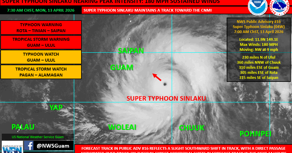
Sounds like Guam dodged a bullet
 www.guampdn.com
(UPDATED) COR 1 at 4 pm, Super Typhoon Sinlaku now stronger than Mawar but 'unlikely scenario' that worst of it will hit Guam
Guam will enter Condition of Readiness 1 at 4 p.m. on Monday, with 180 mile-per-hour Super Typhoon Sinlaku approaching the Marianas and destructive winds possible within 12 hours, the Joint
Geeze a Typhoon that strong could capsize GuamSounds like Guam dodged a bullet
(UPDATED) COR 1 at 4 pm, Super Typhoon Sinlaku now stronger than Mawar but 'unlikely scenario' that worst of it will hit Guam
Guam will enter Condition of Readiness 1 at 4 p.m. on Monday, with 180 mile-per-hour Super Typhoon Sinlaku approaching the Marianas and destructive winds possible within 12 hours, the Joint
")

In that second picture, I'm assuming the higher the number, the higher the Significant Tornado risks? If so, super not comforting, as I'm sitting at an 11. You guys over here do a great job with your weather threads, which is why I typically pop over. I hadn't seen these graphics yet today, so I do appreciate it.
Yes BUT...that is of course not all that goes into it as you can se by looking at the model screenshots that follow it. Significant Tornado risk in well down into Iowa but the models are largely keeping everything north of the border. That being said anywhere within a 2-3 county tier of the border should be keeping weather aware today.In that second picture, I'm assuming the higher the number, the higher the Significant Tornado risks? If so, super not comforting, as I'm sitting at an 11. You guys over here do a great job with your weather threads, which is why I typically pop over. I hadn't seen these graphics yet today, so I do appreciate it.
Right, I get that. Could be an interesting start to our severe storm season here, and sitting behind my desk as an insurance agency owner, only makes me cringe a little bit!Yes BUT...that is of course not all that goes into it as you can se by looking at the model screenshots that follow it. Significant Tornado risk in well down into Iowa but the models are largely keeping everything north of the border. That being said anywhere within a 2-3 county tier of the border should be keeping weather aware today.
That type of weather where my garage floor is soupy.

2 tornado boxes in northern Kossuth and Emmet County. 3 tornado boxes across southern Minnesota , Jackson to Albert Lea.